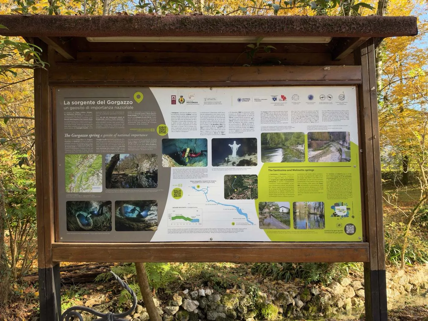
The springs of the Livenza River (the Gorgazzo, Santissima and Molinetto) are a site of considerable geological, scientific and scenic interest. They have been identified and protected as a Geosite by the Friuli Venezia Giulia Region, in collaboration with the Department of Mathematics, Computer Science and Geosciences of the University of Trieste. All three rise at the foot of the south-eastern escarpment of the Cansiglio–Cavallo karst massif, 30–50 m above sea level, and form three branches that flow together to create the Livenza River.
They are one of the most interesting karst hydrogeological systems in Italy and the main outlets of an extensive aquifer, fed by rainwater that collects on the Cansiglio–Cavallo plateau and flows deep underground through fractures and numerous caves. The Gorgazzo spring in particular is Italy’s second-deepest flooded cave: it goes down 222 m below ground level and has about 700 m of passages, mostly vertical. After a long ban, scuba diving here is now regulated by Municipal Council Resolution no. 28 of 16 April 2014.
- MapLocation of the geosite. Tabacco map 1:25,000, sheet 12, authorisation no. 2015.
- Photo of the spring pool among the treesIn every season, the Gorgazzo spring offers spectacular plays of light and transparency. Photo: Sergio Del Mese.
A patch of liquid sky
The Gorgazzo, hidden among trees and rocks, is known locally as “el Buso” [local dialect for “the hole”]. Its clear, icy waters, azure in colour and full of countless reflections, were described by Marinelli in 1877 like this:
“Take the colour of emerald, that of turquoise, that of beryl, and throw them into a sea of lapis lazuli, so that everything melts together and yet each keeps its own character, and you will have the hue of that patch of liquid sky called the Gorgazzo!”
- Photo of a white statue under waterThe statue of Christ, placed 9 m down, can be seen when the water is clear.
- Photo of the spring overflowingThe Gorgazzo spring in flood. Because it is an “overflow” spring, its water only flows away when it spills over the lip.
- Photo of a dry, stony stream bedThe bed of the Gorgazzo stream, dry when it has not rained for ten days or so. In reality the water is still flowing, beneath the surface.
The dives, 1964–2019
The underwater explorations, highly technical and demanding, have been carried out by many cave divers from Italian and international groups. The first dive for which there is a reliable record was made by a cave diver from the Circolo Idrologico Speleologico Friulano on 13 December 1964, to a depth of 21 m. In May 1967 G. Cobol reached 64 m, a depth surpassed the same year by W. May, C. Hayes and S. Piccini, who got down to 80 m. In 1987 L. Russo and M. Martini descended to 108 m.
On 31 December 1992 the dives of the Swiss diver J.J. Bolanz and his team culminated at a depth of 131 m. On that occasion L. Casati also explored a side branch between 90 and 104 m. Casati came back with his team in February 2008 and reached 212 m, which at the time made the Gorgazzo the deepest flooded cave in Italy. In 2019 the Polish cave diver K. Starnawski explored down to 222 m, with large galleries still stretching ahead of him!
- 1964A diver from the Circolo Idrologico Speleologico Friulano, 13 December21 m
- 1967G. Cobol, May64 m
- 1967W. May, C. Hayes and S. Piccini80 m
- 1987L. Russo and M. Martini108 m
- 1992J.J. Bolanz and team, 31 December131 mL. Casati explores a side branch between 90 and 104 m
- 2008L. Casati and team, February212 mThe deepest flooded cave in Italy at the time
- 2019K. Starnawski222 mLarge galleries still continue beyond
- Photo of a diver in a shaft with reddish wallsOne of the first shafts of the Gorgazzo spring during the explorations. The reddish rudist fossils [extinct reef-building molluscs] are clearly visible on the walls: evidence of the ancient warm tropical sea that covered this area until 65 million years ago. Photo: Roberto Rinaldi, Centro Pordenonese Sommozzatori, and University of Trieste archive (CGEB).
- Two photos of divers in underwater tunnelsGalleries of the Gorgazzo. Photos: K. Starnawski, 2019.
- Blue cave profile marked A and BTopographic survey of the Gorgazzo spring, from A, the mouth of the spring, down to B, the deepest point at 222 m. Labels along the profile record the depths reached by Jean Jacques Bolanz (131 m, 1992), Luigi Casati (212 m, 2008) and Krzysztof Starnawski (222 m, 2019).
- Aerial photo with a blue line[No caption on the panel. It shows the route of the cave from above, running from the spring back beneath the wooded slope.]
Geological section
- Karst limestone
- Conglomerate, poorly permeable
- Thrust fault (Polcenigo–Maniago Line)
Simplified geological section of the Cansiglio, showing the area where the springs emerge at the foot of the mountains. Karstified limestone is shown in green and poorly permeable conglomerates in blue. A regional thrust fault, the Polcenigo–Maniago Line, brings the two rock units into contact.
[Redrawn from the panel with English labels.]
The Santissima and Molinetto springs
The Santissima and the Molinetto have average annual temperatures of 9.5 °C and 11 °C respectively. Both are springs formed by an underlying permeability threshold: the conglomerates, the “less permeable” unit, lie beneath the “more permeable” limestones. Both flow all year round. While the Gorgazzo spring has an irregular regime, with high peaks in flow that settle back to normal within a few hours, the Santissima and the Molinetto flow continuously, their water levels vary only a little, and their floods take longer to subside.
In 2007 and 2016 a tracer test was carried out, releasing a tracer into two caves on the Cansiglio plain. It confirmed that the water comes from this plateau, with response times of about a week at the Santissima and Molinetto springs. From the Gorgazzo, on the other hand, there was no definite response.
- Two photos of springs beside a roadLeft: the Santissima spring. Right: the Molinetto. Both can be seen from the road along the foot of the mountains.
Links from the panel’s QR codes
- Watch the Gorgazzo spring videoQR beside the introduction
- Open the VR 360 viewQR beside the cave survey
- Download the geo-guideQR at the bottom right
About this translation
Translated from the Italian on the panel and checked against the panel’s own shorter English text. Words in [square brackets] are translator’s notes, not part of the panel. A few tiny labels on the panel’s cave survey were too small to read in the photo, so the depths come from its main text.
Logos on the panel: Municipality of Polcenigo, Department of the Environment; the Autonomous Region of Friuli Venezia Giulia, which contributed to the initiative through its Geological Service under Regional Law 15/2016; University of Trieste, Department of Mathematics, Computer Science and Geosciences; Unione Speleologica Pordenonese, CAI Pordenone section; Prometeo Ricerche, Casati Team; Centro Pordenonese Sommozzatori; Gruppo Speleologico Sacile, Società Speleologica Italiana; Federazione Speleologica Regionale del Friuli Venezia Giulia; and I Borghi più belli d’Italia, the association of Italy’s most beautiful villages.